
Real estate · Drone photo and video · Vancouver
Real Estate Drone Photography & Video in Vancouver: The Complete Guide
What realtors, developers and sellers need to know before booking a drone shoot in Metro Vancouver: the rules as they stand in 2026, the airspace, the permits, the shots that matter for each kind of listing, and what it costs.

Key findings
- Metro Vancouver has far more listings than buyers. In August 2026 there were 15,798 active listings and 1,869 sales, a sales-to-active listings ratio of 12.3%. For detached homes it was 9.6%. Greater Vancouver Realtors says prices come under pressure when the ratio stays below 12% (GVR1).
- Most listing flights in Metro Vancouver need an advanced certificate. Basic operations are only allowed in uncontrolled airspace, more than 5.6 km from the centre of a certified airport, 1.9 km from a heliport and 30 m from any person (Transport Canada). Much of the Lower Mainland fails at least one of those tests.
- Every drone from 250 g to 25 kg must be registered and flown by a certified pilot. Fines for individuals run up to $1,000 for flying without a certificate and $5,000 for an unregistered drone; for corporations, up to $5,000 and $25,000 (Transport Canada).
- The ceiling is 122 m (400 ft), about a 30-storey building. Flying higher needs a Special Flight Operations Certificate, so a drone won't show the view from the top floors of a downtown tower.
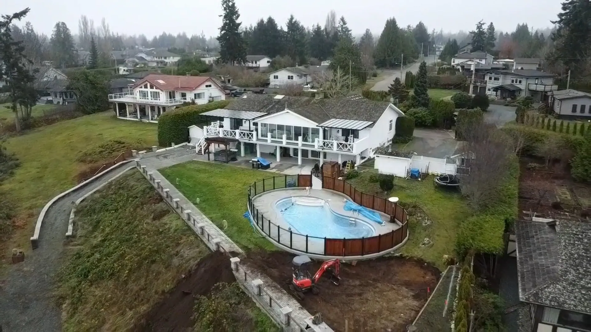
A photo from the curb shows a house. An aerial shows what the buyer is paying for: the lot, the view, the street and what's a short walk away. In Vancouver that's often most of the price.
I started out running ads for realtors, developers and builders before Debut focused on contractors, so listing photos are where my work began. This guide covers when a drone is worth it for a listing, what Transport Canada's rules say in 2026, how airspace works around YVR and the other airports, and how to plan the shoot so the photos help sell the home. It draws on Transport Canada's current rules, Greater Vancouver Realtors' August 2026 numbers and the more than 300 photoshoots we've done for contractors and developers.
Why aerials matter more in a slow Vancouver market
When homes sell in a weekend, almost any photos will do. That isn't the market in 2026. Metro Vancouver had 15,798 active listings in August against 1,869 sales, 20.7% below the 10-year August average. The sales-to-active listings ratio, the share of listings that sold that month, was lowest for detached homes, the listings where a lot, a yard or a view does the most selling.
| Property type | Benchmark price | Change from August 2025 |
|---|---|---|
| Detached | $1,799,400 | -7.2% |
| Townhouse | $1,028,800 | -4.4% |
| Apartment | $686,200 | -6.6% |
| All residential | $1,081,900 | -5.6% |
With prices down and buyers taking their time, a listing has to earn the showing online. On a $1.8 million detached home, the drone shoot is a rounding error next to one price reduction.
Do you need a licence to fly a drone for real estate in Canada?
Yes, for any drone from 250 g to 25 kg. Transport Canada requires the drone to be registered and marked, and the pilot to carry a drone pilot certificate on every flight (Transport Canada). There are two certificates for small drones, and the conditions of the flight decide which one you need:
| Condition | Basic operations | Advanced operations |
|---|---|---|
| Minimum age | 14 | 16 |
| To qualify | Online exam | Online exam and an in-person flight review |
| Airspace | Uncontrolled only | Controlled too, with an RPAS Flight Authorization from NAV CANADA |
| Distance from people | More than 30 m horizontally | Within 5 m or over people, if the drone meets the safety requirements |
| Certified airports | More than 5.6 km from the centre | Closer, with permission |
| Heliports | More than 1.9 km from the centre | Closer, with permission |
| Height | Under 122 m (400 ft) | Under 122 m (400 ft) |
Drones under 250 g (microdrones) don't need a certificate or registration, but they have their own rules and still can't fly at advertised events. They also get pushed around by wind, which matters on an exposed lot or near the water.
The rules last changed in 2025. Registration went to $10 per drone on April 1, 2025, and from November 4, 2025 advanced pilots can fly "sheltered" operations close to a structure (Transport Canada). None of that removes the need for permission in controlled airspace.
Vancouver airspace: why most listing flights need permission
Much of the Lower Mainland sits inside controlled airspace or within the 5.6 km and 1.9 km rings around airports and heliports: Vancouver International (YVR), Boundary Bay, Pitt Meadows, Abbotsford, and the harbour float plane and heliport traffic downtown. A detached home in Richmond, most of Vancouver's west side and large parts of Delta, Surrey and Abbotsford can all fall inside those zones.
For those flights the pilot needs an advanced certificate and an RPAS Flight Authorization from NAV CANADA, requested through the NAV Drone app (Transport Canada). Permission can come with conditions, like a lower maximum height, so the request goes in before the shoot is booked, not the morning of.
Parks, neighbours and city permits
- City permits. If a shoot needs a City of Vancouver film permit, adding a drone means carrying aviation liability insurance on top of general liability, and the city can restrict flight paths over some areas and parks to protect wildlife such as nesting birds (City of Vancouver).
- National parks. You can't take off or land in one without the superintendent's permission (Transport Canada).
- Neighbours. Under basic rules the drone stays more than 30 m from anyone who isn't part of the shoot. Frame shots so neighbours' yards and windows aren't the subject, and tell them before you fly. The city also reminds anyone filming that provincial and federal privacy laws apply to drones.
- Events and emergencies. No flying near advertised events without a special certificate, and never inside a police or first-responder perimeter.
What to shoot, by type of listing
The best aerials answer the question a buyer can't answer from the street. That question changes with the property:
| Listing | Must-have aerials | What it answers for the buyer |
|---|---|---|
| Detached home | Front three-quarter view at 20 to 40 m; top-down of the lot; the street and the nearest park or school | How big is the lot, and what's around it? |
| Acreage and rural | Top-down with the property lines; outbuildings, access road and water; a wide shot of the setting | Where does the land start and stop? |
| Townhouse or strata | The complex in its neighbourhood; amenities; the walk to transit or shops | What's the neighbourhood like? |
| Laneway or development lot | Top-down with the lot width; the lane; nearby new builds | What could be built here? |
| View property | The view from roughly the height of the main windows, then a pull-back to the house | What will I see every morning? |
Get the ground photos too. Aerials sell the setting; buyers still want to see the kitchen.
Timing and settings that work on the West Coast
- Book for the weather, not the calendar. Rain and strong wind ground the shoot, and grey skies flatten the photos. We reschedule rather than deliver dull aerials.
- Morning or late-afternoon light. A low sun shows the shape of the roof and the yard; midday light is flat and harsh.
- Height by purpose. 20 to 40 m for the house itself, higher for the neighbourhood and the view. Too high and the house becomes a dot.
- Shoot raw and bracket. Raw files and bracketed exposures keep the sky and the shadows in one photo after editing.
- Slow, steady video. Slow reveals and pull-backs read as calm and expensive. Fast spins look like a toy.
- Clear the property first. Bins, cars in the driveway and hoses on the lawn are obvious from above.
Common mistakes
- Flying in controlled airspace without a NAV CANADA authorization, which puts the pilot and whoever hired them at risk of a fine.
- Hiring someone without an advanced certificate for a property that needs one.
- Only shooting from high up, so the house gets lost in the frame.
- Crooked horizons and wide-angle distortion left in the final photos.
- Leaving out the ground photos and the interior.
What a real estate drone shoot costs in Vancouver
Our own prices, as of September 2026:
| Option | Price | What you get |
|---|---|---|
| Single shoot | $800 | 10+ edited photos, a highlight video and the raw drone footage, for one location |
| Drone plan | $1,799 | 3 photoshoots, 20+ edited photos, 2 to 3 videos and drone footage across multiple locations |
What moves the price anywhere: travel, the number of locations, video length and editing, and whether the property sits in controlled airspace, which adds planning time. Before you book anyone, ask for their certificate level and whether they'll handle the NAV CANADA request.
Questions contractors ask
Do you need a licence to fly a drone for real estate in Canada?
Yes, for any drone from 250 g to 25 kg: the drone must be registered and the pilot needs a Transport Canada drone pilot certificate. Near airports, in controlled airspace or close to people, that has to be an advanced certificate.
Can you fly a drone near YVR?
Only with an advanced certificate and an RPAS Flight Authorization from NAV CANADA, requested through the NAV Drone app. The same goes for anywhere within 5.6 km of a certified airport or 1.9 km of a heliport.
How high can a drone fly in Canada?
122 m (400 ft) above the ground, roughly a 30-storey building. Flying higher needs a Special Flight Operations Certificate.
Do I need to register a drone under 250 g?
No. Microdrones under 250 g don't need registration or a pilot certificate, but they have their own rules and can't fly at advertised events.
How much does real estate drone photography cost in Vancouver?
Our single shoot is $800 for 10+ edited photos, a highlight video and the raw footage for one location. Travel is extra.
Can a drone fly over the neighbours' houses?
Under basic rules the drone must stay more than 30 m horizontally from people who aren't part of the shoot. Flying closer or over people needs an advanced certificate and a drone that meets the safety requirements. Keep neighbours' yards and windows out of the frame either way.
Glossary
- Basic operations
- Flying a 250 g to 25 kg drone in uncontrolled airspace, in sight, more than 30 m from people, 5.6 km from certified airports and 1.9 km from heliports.
- Advanced operations
- Any flight that breaks a basic condition, such as controlled airspace or flying close to people. Needs the advanced certificate.
- RPAS Flight Authorization
- NAV CANADA's permission to fly a drone in the airspace it controls, requested through the NAV Drone app.
- SFOC
- Special Flight Operations Certificate: Transport Canada's permission for flights outside the normal rules, such as above 122 m.
- Microdrone
- A drone under 250 g. No certificate or registration, but its own set of rules.
- Sales-to-active listings ratio
- Sales in a month divided by the listings active that month. GVR reads under 12% as downward pressure on prices and over 20% as upward.
How we put this together
- Market data
- Greater Vancouver Realtors, August 2026
- Drone rules
- Transport Canada, checked September 2026
- Our experience
- 300+ photoshoots for contractors and developers
- Updated
- September 29, 2026
Drone rules are from Transport Canada's pages on basic and advanced operations, where to fly, flying safely and legally and the 2025 changes, checked on September 29, 2026. Rules change, so check Transport Canada before any flight.
Market numbers are from Greater Vancouver Realtors' August 2026 release1, published September 1, 2026. City permit rules are from the City of Vancouver's film and photography permits page.
Prices and shot lists are our own: Debut Marketing's published drone prices and the shot lists we use on listing and development shoots.
Cite this page
Striemer, E. (2026, September 30). Real Estate Drone Photography & Video in Vancouver: The Complete Guide. Debut Marketing. https://debutmarketing.ca/drone-real-estate
The numbers on this page are Debut Marketing's 2026 findings. We combined our own campaign data with the studies, ad platforms and agencies listed under Sources, took the typical figure for each number and put it in Canadian dollars. You're welcome to use them: please credit Debut Marketing and link to this page.
Sources
- 1 Greater Vancouver Realtors (2026). Home sales continue downward trend to close the summer (August 2026 statistics). Metro Vancouver sales, listings and benchmark prices, released September 1, 2026.
- 2 Transport Canada. Basic and advanced drone operations. The conditions for each pilot certificate, checked September 29, 2026.
Other links in this guide
- tc.canada.catc.canada.ca/en/aviation/drone-safety/learn-rules-you-fly-your-drone/flying-your-drone-safely-legally
- tc.canada.catc.canada.ca/en/aviation/drone-safety/2025-summary-changes-canada-drone-regulations
- tc.canada.catc.canada.ca/en/aviation/drone-safety/learn-rules-you-fly-your-drone/where-fly-your-drone
- vancouver.cavancouver.ca/doing-business/film-permits.aspx
- tc.canada.catc.canada.ca/en/aviation/drone-safety/learn-rules-you-fly-your-drone/drone-operation-categories-pilot-certificates/advanced-operations
Keep reading
- Construction Drone Photo and Video Which drones to use, Canada's updated drone rules and how to get useful footage. Read it
-
 Construction Website Statistics 2026 133 Canadian construction companies scored on their websites and Google profiles: the grades, the gaps and the fixes. Read it
-
 Painter Website Statistics 2026 132 Canadian painting companies scored on their websites and Google profiles: the grades, the gaps and the fixes. Read it